

Faq
Q: WHAT DOES A BUILDING DESIGNER DO?
A building designer is a professional who specializes in the design and planning of buildings. Their role encompasses various aspects of the design process, including conceptualization, space planning, and technical detailing. Here are some of the key responsibilities and tasks that a building designer typically performs:
- Concept Development: Building designers work closely with clients to understand their needs, preferences, and project requirements. They translate these requirements into design concepts, taking into account factors such as functionality, aesthetics, sustainability, and budget.
- Building Design: Building designers create detailed architectural plans and drawings, including floor plans, elevations, and sections. They consider structural integrity, building codes, and regulations while developing the design. They also incorporate elements such as lighting, ventilation, and accessibility into their designs.
- Material and Finishes Selection: Building designers advise clients on suitable materials, finishes, and fixtures that align with their design vision and project goals. They consider factors such as durability, aesthetics, maintenance requirements, and budget when making recommendations.
- Building Codes and Regulations: Building designers have knowledge of local building codes, regulations, and planning requirements. They ensure that their designs comply with these guidelines, obtain necessary permits, and coordinate with regulatory authorities as needed.
- Collaboration: Building designers often work in collaboration with other professionals involved in the construction process, such as architects, engineers, and contractors. They coordinate with these stakeholders to ensure that the design is feasible and implemented correctly.
- Project Management: Building designers may oversee projects, ensuring that design intentions are accurately translated during construction. They may provide ongoing support, clarifications, and revisions as required.
Q: WHAT AREAS DOES THE HARGREAVES DESIGN GROUP SERVICE?
We offer our services to the whole of Victoria & Western Australia. We have dealt with many of the councils in Melbourne, Perth & Bunbury Regions. We have completed projects from Yarrawonga to Inverloch, Mansfield to Foster, Bunbury to Port Hedland. No area of Victoria or Western Australia is too hard for us so give us a call & let us help you out. Additionally we are also licensed to undertake residential work in NSW.
Q: WHAT ARE THE ADVANTAGES OF HAVING AN INDEPENDENT DESIGNER PRODUCE MY PLANS INSTEAD OF A BUILDING COMPANY?
Choosing an independent Building Designer for your dream home offers these advantages:
- Customized Design: Building Designers specialize in tailoring designs to your unique vision and lifestyle, ensuring a personalized home. You have full control & can design beyond some builders comfort zones.
- Focus on Functionality: Building Designers prioritize practicality, optimizing space utilization and creating a functional living environment. Builder’s designs are primarily structured to achieve a low advertising build cost. Extras that are required for normal living often have to be added by variation often blowing out the build cost.
- Client Ownership: Independent Building Designers grant clients full copyright ownership of their design, allowing you to have complete control over your home. This allows you to shop your design around to a range of builders for pricing. If your design is done by a builder, then that builder owns the copyright. If the price is not attractive once final plans are produced you are back to square one.
Q: HDG USES REVIT DESIGN SOFTWARE. WHAT ARE THE ADVANTAGES OF 3D DESIGN OVER 2D DESIGN?
3D design offers several advantages over 2D design, particularly in the fields of architecture, engineering, and product design. Here are some reasons why 3D design is often considered superior:
- Enhanced Visualization: 3D design allows for a more realistic representation of objects and spaces, providing a clearer understanding of how they will appear in the real world. It enables the visualization of depth, scale, and proportions, aiding in better decision-making and communication.
- Improved Spatial Understanding: With 3D design, users can explore and analyze a design from different angles and perspectives. This helps in understanding spatial relationships, identifying potential issues, and optimizing the layout or arrangement of components.
- Increased Design Accuracy: 3D design tools provide precise measurement capabilities and accurate representations of objects, making it easier to design with accuracy and ensure components fit together properly. This reduces errors, rework, and the associated costs.
- Efficient Design Iteration: 3D design enables rapid prototyping and iteration by allowing users to quickly modify and update the design. Changes made in 3D automatically update related components, saving time and effort compared to manually adjusting multiple 2D drawings.
- Clash Detection and Simulation: 3D design software often includes features like clash detection and simulation, which help identify conflicts or collisions between different elements of a design. This allows issues to be resolved early in the design process, reducing the likelihood of errors during construction or manufacturing.
- Enhanced Communication and Collaboration: 3D models are more visually engaging and easier to understand than 2D drawings, making it simpler to communicate design intent to clients, stakeholders, and team members. 3D models also facilitate better collaboration and interdisciplinary coordination among professionals.
- Realistic Visualization and Presentation: 3D design tools offer capabilities for realistic rendering, lighting effects, and virtual walkthroughs, allowing users to create immersive visualizations and presentations. This helps clients and stakeholders better envision the final product or space.
Q: WHAT IS INCLUDED IN MY WORKING DRAWINGS SET?
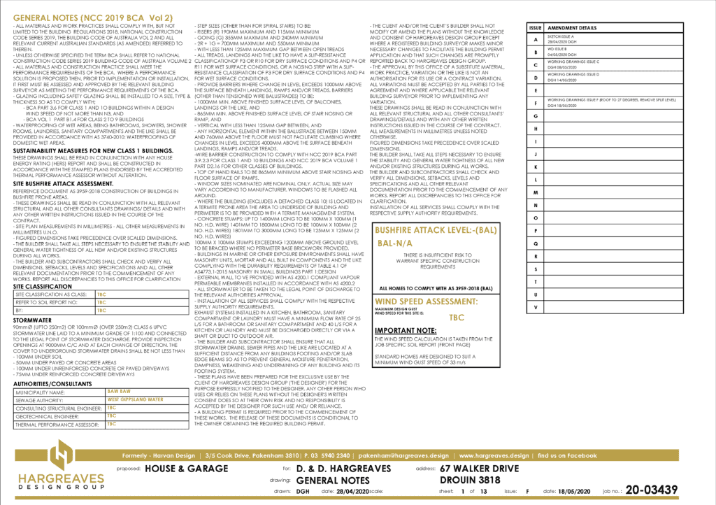
The ‘General Notes‘ sheet is normally glossed over by most clients but this is important in listing areas of compliance with the current Building Regulations. We identify relevant governing bodies, external consultants used, bushfire attack levels & wind speed ratings for the site. A list of amendments to the plans is also kept to keep track of who has worked on the file & when. Every time the drawing set is updated a new issue it is recorded here.
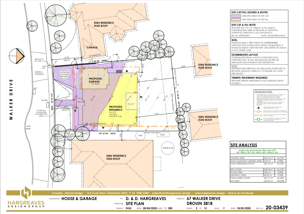
The ‘Site Plan‘ sheet identifies the positioning of the house on the site & in relation to neighbouring developments. This is important if the neighbours are existing as your front setback is often determined by an average of the houses either side of your site.
The amount of cut & fill required to provide a level building platform is shown shaded to allow the builder to calculate volumes of earth to excavate out and/or import to site. These are included in the infamous ‘site costs’ which are added to your building contract.
Easements (areas which are set aside for council & sewerage use) are noted on the plan along with the size, depth & offset of any pipes within. Legal points of discharge are also shown for storm water & sewerage connections as well as the location of down pipes & drainage pipe runs to connect to them.
A table indicating area of the site covered by buildings & hard cover like driveways & paving is shown in a table. This will indicate compliance with site coverage & green area regulations imposed by council planning schemes.
Along with all this there are over 20 other criteria to take into account including driveway gradients, overlooking, overshadowing, neighbour’s northern windows, wall heights on boundary, minimum setbacks & encroachments, private open space, carparking, maximum building height, site permeability, & solar access….just to name a few.
A small miscalculation at this stage can cost you big time during the building permit process.
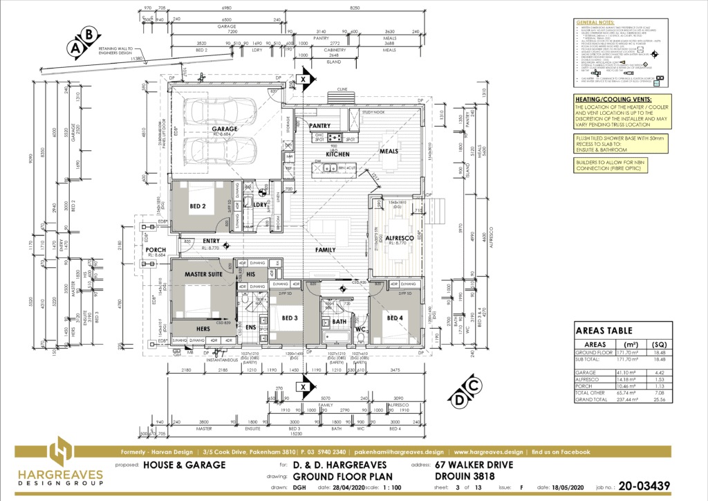
The ‘Floor Plan‘ sheet is the most frequently referred to sheet of the whole drawing set. On this page the layout of the rooms, structure of the walls & cabinetry items are specified. Most of the following sheets in the set refer in some way back to the floor plan. Section lines are cut which reference cross sections on other sheets. The importance of clear & concise dimensioning is paramount to ensure the builder knows the exact sizes of each room for set out purposes. Window and door sizes are noted & placement of smoke detectors, manholes and exhaust fans shown for compliance. Section lines are cut which reference cross sections on other sheets. Floor levels are shown here also to reference back to the site plan & indicate any change in floor levels. External services like water taps, recycled taps, clotheslines, meter boxes, gas meters & hot water services are located to demonstrate compliance. Some details are shown which are often overlooked but make all the difference in the finished product. Some of these include return air vent locations for ducted heating, deepened fridge space to allow for the fridge to be flush with the cabinets, cavity door pockets clear of wall plumbing & cabinetry drawer units shown to control what is visible when Walk in Robe doors are left open. Last, but certainly not least, is the location of down pipes to allow for storm water to be taken away effectively. Most houses do not have enough of these & it can lead to overflowing gutters every time it rains.
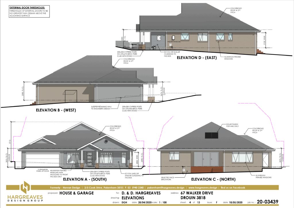
The ‘Elevations‘ sheet is where our clients really start to understand what their house will look like when built. However, sometimes this sheet can be misleading. The idea of detailing elevations is for each orientation of the house to be notated & dimensioned externally. The misleading part is you have to be omnipresent to see it this way. The elevation assumes that your eye is perpendicular to all points of the building at the same time. The only time your windows will look symmetrical, or centred under the ridge, is on the elevation because on site your eye will never see it like this in real life. Important things notated on the elevations are allowable boundary height profiles (shown in pink), floor to ceiling height, overall building height, window head or sill heights, extent of external cladding, services locations & roof pitch. The cut & fill of the land is shown to indicate floor levels & cut levels in relation to the natural surface level. Retaining walls should also be shown along with retention of soil behind the slab edge beams as is the case on this sheet. As we use Revit software, which can accurately locate the position & orientation of the building, shadows can be shown at any day of the year or time of the day. We can show the elevations in single line or fully coloured (a shown here) depending on the builder’s/client’s preference.
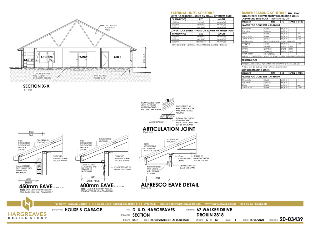
The ‘Section & Details‘ sheet is the most unloved sheet in the drawing set. Clients mostly don’t understand it, builders sometimes overlook it & engineers can ignore it. However, the information on this sheet is very important for regulatory compliance & building inspections. It ensures the builder is using the right details when constructing certain areas of the house. Most good builders will know exactly how to build the standard details shown on this sheet but they do tend to vary from builder to builder. Details of lintels over garages, for example, are constructed in several different way depending on the garage wall & roof structure. There may be one or more sections through the house depending on the requirement to demonstrate two or more construction techniques in various parts of the building. Whilst this sheet used to include slab edge beam, weep hole waterproofing & other standard details, these have over time been outsourced to engineers & other consultants who specialise in these areas & have the insurance to cover the structural design. The Timber Framing Schedule indicates all timber sizes to be used in the house. The caveat on this is that, if the wall framing is over 2.7m high, then the whole timber structure will need to be justified by a structural engineer. Roof trusses are usually provided with truss computations from the truss company to justify their spans. Likewise, steel lintel spans to support brickwork over external windows & doors need to be engineers if the spans exceed those shown in the external lintel schedule.
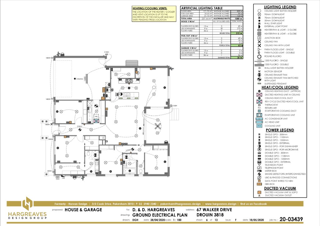
The ‘Electrical Plan‘ details the electrical fixtures & fittings placed in your house. All power points, light fittings, TV points, data points & switching for lights are shown on this plan. Also required is the total number of light fittings & their wattage to ensure the total wattage complies with the building regulations. This is indicated by the ‘Artificial Lighting Table’ which shows the maximum wattage allowed per m2 for each area of the house. Ducted heating points are also shown either in the ceiling or floor depending on the style of house. Location of the heating unit in the ceiling is indicated close to the manhole. The return air & thermostat location is important as nobody wants a return air grille as a feature in their house.
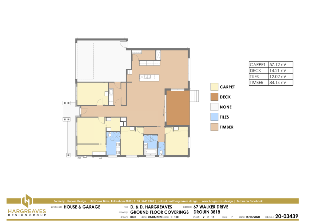
The ‘Floor Coverings‘ plan identifies the different floor coverings in each room of the house. This is mainly required for the completion of the 6 star energy rating which takes into account the different thermal properties of each floor covering. The areas shown are accurate & allow clients to order their floor coverings with accuracy. You will find, however, that the flooring suppliers won’t trust the figures shown & will still measure the plan with a ruler to estimate their own areas. Depending on the flooring chosen a rebate in the slab may be required to ensure there are no tripping hazards where different coverings meet. These plans indicate tiles through the shower recesses which will mean a 50mm recess in the slab to create fall to the drainage point.
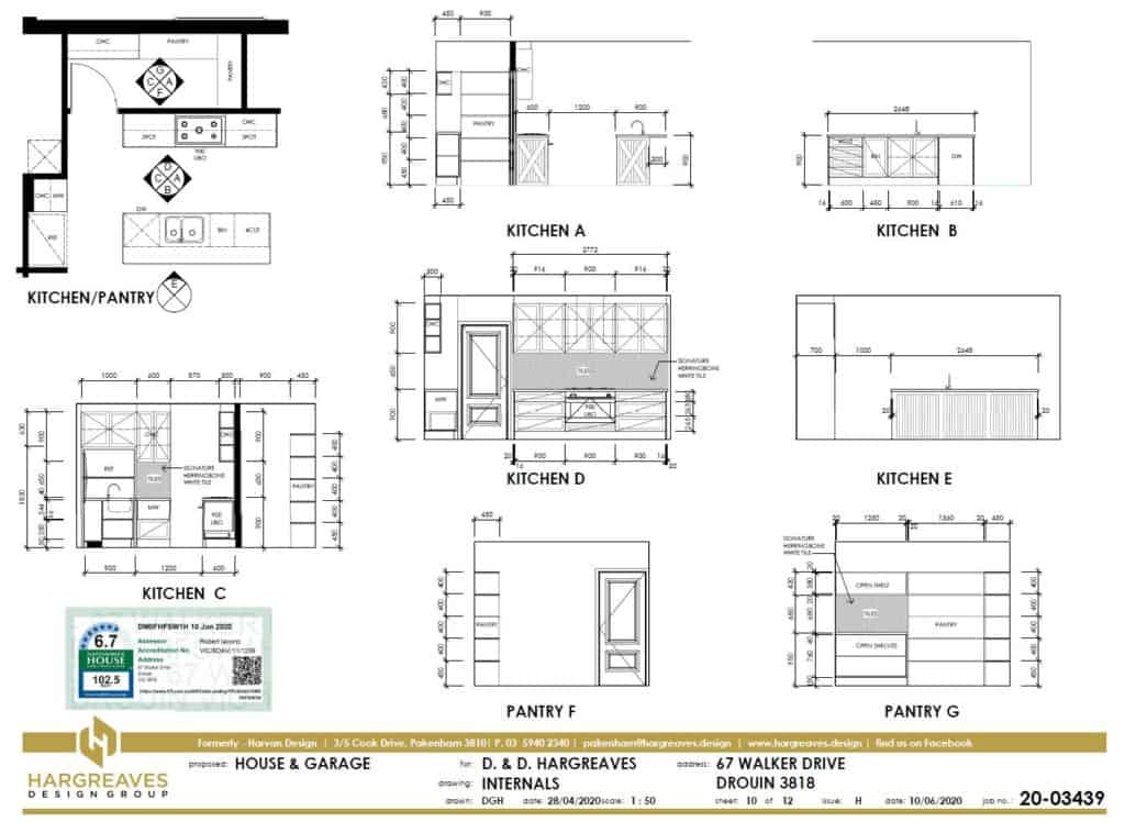
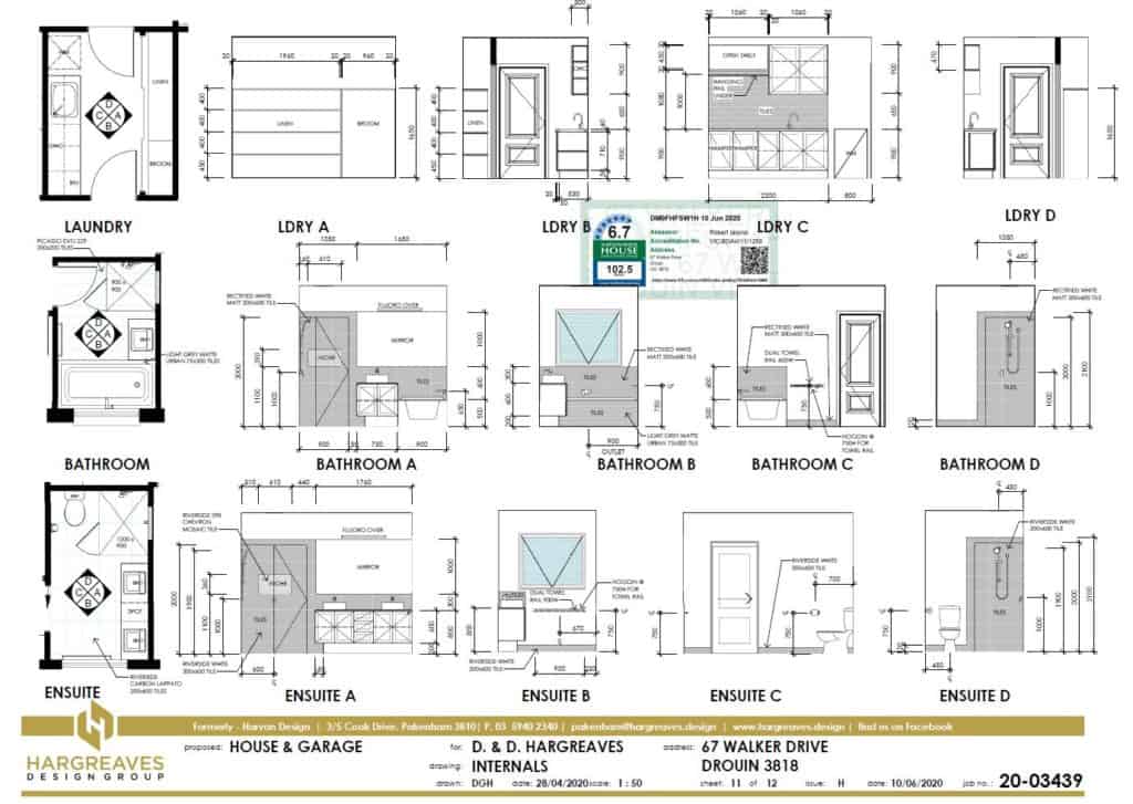
The ‘Internal Elevations‘ sheets are ancillary to the main working drawings set. They are not required in the minimum working drawings set to gain a building permit. They are, however, requested often in order for our clients to be able to visualise the internal cabinetry items in their wet areas. If you are having plans done in order to get quotes from a number of builders, it is always a good idea to have internal elevations of your wet areas & cabinetry done. This way each builder will be pricing the same cabinetry details & comparison of quotes is much more relevant. With the wide array of tiling choices available today the detailing on this sheet can make sure mistakes are not made due to the tiler doing what he thought you wanted. Having these sheets as part of your set also helps remove necessary clutter on the floor plans trying to cover cabinetry details by notes. Most robes & walk in robes are fitted out these days & the detailing should be particular to each client’s needs.

Q: WHY USE A DESIGN MATTERS MEMBER?
Clients may consider using a member of Design Matters, an organization representing building designers in Australia, for several reasons:
- Professional Standards: Design Matters members are bound by a code of conduct, ensuring they adhere to high professional standards. They are committed to providing quality services and maintaining ethical practices in their work.
- Expertise and Experience: Design Matters members often have extensive experience and expertise in building design. They stay updated with industry trends, regulations, and best practices, enabling them to provide informed design solutions that meet client needs.
- Design Creativity: Design Matters members are known for their creative and innovative approach to design. They can offer fresh perspectives and original design concepts that can make a project stand out while still addressing practical considerations.
- Collaboration and Communication: Design Matters members typically value strong communication and collaboration with clients. They listen to their clients’ requirements, goals, and visions, and work closely with them throughout the design process to ensure their satisfaction.
- Local Knowledge: Design Matters members are often familiar with local building regulations, planning schemes, and environmental factors specific to the region. This knowledge can be valuable in navigating the complexities of the local planning and approval processes.
- Industry Network: Being part of Design Matters provides access to a network of professionals in the building and design industry. This can facilitate collaboration with other experts, such as builders, engineers, and suppliers, to create a comprehensive design team.
It is important to note that while Design Matters membership can be an indicator of professionalism and expertise, it is still essential to evaluate individual members based on their specific qualifications, track record, and alignment with your project requirements.
Q: IS MY HOUSE IN A BUSHFIRE AREA?
Bushfire controls, also known as bushfire management controls or regulations, are measures put in place to reduce the risk and impact of bushfires on properties and communities. These controls aim to enhance the safety of buildings and the surrounding environment in areas prone to bushfires. The specific bushfire controls can vary depending on the region or jurisdiction, but they typically include:
- Planning and Zoning: Certain areas may be designated as bushfire-prone zones or have specific planning overlays that require additional considerations for development. These controls may restrict building in high-risk areas or mandate specific construction standards.
- Building Design and Construction: Bushfire controls often specify requirements for building design and construction materials. These can include measures such as ember protection, fire-resistant building materials, and the installation of bushfire-resistant windows, doors, and roof coverings.
- Vegetation Management: Controls may include requirements for managing vegetation around properties to reduce fuel loads and prevent the spread of fires. This can involve clearing vegetation, maintaining fire breaks, and implementing landscaping strategies that minimize the risk of fire spread.
- Access and Egress: Bushfire controls may stipulate requirements for access roads, driveways, and evacuation routes to ensure safe ingress and egress during fire events. This can include specifications for road width, turning circles, and clearance of vegetation along access routes.
- Water Supply and Firefighting Infrastructure: Controls may require properties in bushfire-prone areas to have adequate water supply for firefighting purposes, such as the provision of fire hydrants, water tanks, or swimming pools that can be used as emergency water sources.
It’s important for property owners and developers to be aware of and comply with the bushfire controls applicable to their region. These controls are intended to minimize the risk to life and property in bushfire-prone areas and enhance community resilience to bushfires.
Q: IS A BUILDING PERMIT REQUIRED?
Building permit requirements are now based on the scope of building work rather than the value of the building work. This now implies the need for small jobs like internal renovations, garages, carports and pergolas to have a permit. If you are unsure if your project requires a permit feel free to contact us for clarification
Q: BUILDING PERMIT DETAILS & PROCESS?
Once you have lodged your application with a building surveyor, they will check for compliance with the regulations and can issue a permit with or without conditions. In Victoria the building surveyor who issues the permit must follow the project through to the end, carrying out building inspections and issue an occupancy permit or a certificate of final inspection on completion of your building work. This process varies from state to state so let us help you out with our local knowledge.
Q: PLANNING PERMIT APPLICATION & PROCESS?
A pre-application meeting with council is the starting point and will provide a guide of councils’ opinions and may raise any concerns they may have. Lodging the application and having it allocated to a planner is the next step. The planner will carry out an assessment of the application. The application is then sent to advertising and objections can be lodged. The objections are then considered and the planner may take the application to a peer meeting for a decision or if possible, recommend an outcome for the proposals. A fact sheet detailing the planning process is issued with all of our written quotes where planning is applicable.
Q: WHAT IS RESCODE?
ResCode is a set of residential planning guidelines and standards in the state of Victoria, Australia. It is designed to ensure that new residential developments meet certain quality and design standards while promoting sustainable and livable communities. ResCode provides guidance on various aspects of residential development, including setbacks, site coverage, building height, overshadowing, privacy, and landscaping.
ResCode consists of two parts: ResCode Clause 54 and ResCode Clause 55. Clause 54 focuses on the design of single dwellings, while Clause 55 covers medium-density and apartment developments. These clauses outline specific requirements and performance objectives that must be met for development proposals to be considered compliant with ResCode.
ResCode is used by local councils and planning authorities in Victoria to assess and regulate residential development applications. It aims to ensure that new housing developments contribute positively to the streetscape, provide adequate amenity for residents, and maintain the character and livability of established neighborhoods.
It is important for homeowners, building designers, and developers to familiarize themselves with ResCode when planning and designing residential projects in Victoria. Compliance with ResCode is typically required as part of the planning permit process and ensures that developments align with the state’s planning policies and objectives.
Q: WHAT ARE THE 'R' CODES PLANNING CONTROLS?
R codes are a set of planning controls used by the Western Australian government to guide development and subdivision in residential areas, with the aim of promoting sustainable and affordable living. These codes cover aspects such as lot sizes, building setbacks, and minimum building standards.
Q: WHAT ARE THE 6 STAR ENERGY REQUIREMENTS?
A minimum 6 Star energy rating (Thermal Performance Report) is required for all new homes, home renovations, alterations, additions and relocations in Victoria, WA & Tasmania. A 6 Star energy rating is about good layout, simple adjustments at the concept sketch stage, insulation adjustment and designing a house to suit the site. This requirement will change to 7 stars in Victoria in October 2023 with Tasmania following suite 1 year later.
As preferred designers for Durisol Australia we are able regularly achieve rating of 9 stars & better. Durisol, incorporates concrete filled core walls with concrete slab & roofing, along with triple glazed windows, to achieve a building fabric requiring no heating or cooling all year around.
Q: IS MY LAND IN A FLOOD PRONE AREA?
Floods have more recently affected large areas of metropolitan and rural Victoria . As such the flood zoning has been changed to accommodate the possible risks. Local councils & the MMBW can provide further information on these requirements as they add ‘Land Subject to Inundation’ overlays in their planning scheme to susceptible areas. Occasionally the local council will also require report & consent for overland flows in certain areas.